Study case Dorset

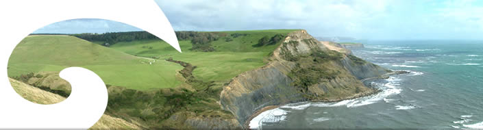
The Dorset Marine Management Area lies between Durlston Head and Portland Bill (out to 12 nautical miles), covering an area of 953 km².
As there are many ways to define the landward boundary of the MMA, this has not been established yet and it will be up to the Marine Spatial Planning Task and Finish Group to decide where it should be.
The majority of the seabed in the MMA consists of sublittoral sands and gravels, though there are some areas of rocky ledges and outcrops.
Conditions range from heavily wave-exposed and tide-swept areas around Portland Bill to very sheltered deep mud habitats in Portland Harbour.
The uses of the area are as varied as its habitats – commercial fishing, military use, recreational use (diving, angling, sailing etc), shipping/ports,
to name but a few - and it is directly adjacent to the Jurassic Coast World Heritage Site.
It is also the location of the 2012 Olympic Games sailing events.
The Marine Management Area is one of the key components of the C-SCOPE Project in Dorset.
The objective is to establish a working coastal and Marine Spatial Plan (MSP) for the MMA which will include, and be developed from, the following elements:
- A detailed seabed map for the Dorset MMA.
- A Dorset landscape/seascape capacity report.
- A Dorset offshore renewable capacity study report.
- A detailed report on the Dorset Coastal Explorer Planning and its sectoral uses
This Plan will be devised using a ‘bottom up’ approach, driven by the MSP Task and Finish Group, DCF members and other coastal users. Decision making will be helped by the development of a GIS based planning tool, called Coastal Explorer planning that will be populated with data on the ecology, current uses and land/seascape features of the MMA.

